


 9 / 130

[
]9
access
to
water
and
sanitation
for
all
Efforts towards SDG 6 moreover enable interlinkages
across all other SDGs, indirectly contributing to achiev-
ing several. IHP is providing knowledge and initiatives to
improve livelihoods, and address food security, human health
and well-being, education for sustainable development, and
many others. For example, its thematic focus on water quality
supports increased agricultural sustainability, improved
water safety, strengthens scientific and technological knowl-
edge for more sustainable patterns of consumption and
production, and reduces marine pollution, thereby contrib-
uting to SDGs 2, 3, 12, and 14. IHP’s work on ecohydrology
aims to improve understanding of the connection between
hydrological and biological process to ensure water security.
Its work in this context addresses water pollution in coastal
and urban environments, integrates ecosystem approaches
to prepare for extreme hydrological events, and assesses
the relationship between ecosystem functions and aquatic
systems, contributing to SDGs 3, 11, 13, 14, and 15, among
others. In providing water education and capacity building
opportunities for youth and water professionals, IHP further
impacts SDGs 8 and 16 by supporting education of youth
and strengthening institutional governance. Overall, IHP’s
Strategy encompasses the three dimensions of sustainable
development – social, environmental and economic.
Gender equality, which is represented by SDG 5, also repre-
sents one of UNESCO’s global priorities. Recognising the
importance of integrating gender considerations with formu-
lating solutions for water access and management, UNESCO
contributes to achieving SDG 5 through strengthening
women’s capacities in scientific domains and promoting
effective participation of women in decision-making at all
levels. The UNESCO World Water Assessment Programme
(WWAP) developed a Gender and Water Toolkit to collect
sex-disaggregated data aimed at producing scientific evidence
on gender inequalities related to water and integrating these
findings into the development and implementation of rele-
vant policies. Better understanding the relationship between
gender and water contributes to strengthening social inclu-
sion, eradicating poverty and advancing environmental
sustainability.
UNESCO’s broad mandate, which extends across five
sectors, uniquely positions IHP to benefit from multidis-
ciplinary and transdisciplinary expertise and integrate a
cross-sectoral approach towards achieving the SDGs. In addi-
tion, IHP’s impact is multiplied through the contribution of
the UNESCO Water Family, a unique network of institutions
which comprise more than 3,000 professionals working in
the field of water globally and supporting the implementa-
tion of IHP-VIII and UNESCO’s overall strategic goals and
priorities.
Recently, UNESCO developed and launched a Water
Information Network System (WINS), an open-access platform
which compiles information on the water cycle from global
information sources, including the UNESCO Water Family.
The data collected by WINS will be critical in monitoring
SDG 6 indicators and in supporting Member States in making
informed decisions about water resource management.
As peace lies at the heart of UNESCO’s mandate, IHP’s
Strategic Plan explores the fundamental nexus between
water and peace. In this context, IHP has for many years been
devoted to promoting water cooperation, and led the coor-
dination of the UN International Year of Water Cooperation
(IYWC) in 2013. In spite of public fears of “water wars”, in
reality, cooperation over shared water resources is more
frequent than is conflict. The goal of IYWC was therefore
to start paving the path for a more peaceful and sustainable
future through finding a common purpose around freshwater
amidst the diversity of interests and perspectives.
"
)
"
)
"
)
"
)
"
)
"
)
"
)
"
)
"
)
"
)
"
)
"
)
"
)
"
)
"
)
"
)
"
)
"
)
"
)
"
)
"
)
"
)
"
)
"
)
"
)
"
)
"
)
"
)
"
)
"
)
!
(
!
(
!
(
!
(
!
(
!
(
!
(
!
(
!
(
!
(
!
(
!
(
!
(
!
(
!
(
"
)
"
)
"
)
"
)
"
)
"
)
"
)
"
)
"
)
"
)
"
)
"
)
"
)
"
)
"
)
"
)
"
)
"
)
"
)
"
)
"
)
"
)
"
)
"
)
"
)
"
)
"
)
"
)
!
(
!
(
!
(
!
(
!
(
!
(
!
(
!
(
!
(
!
(
!
(
!
(
!
(
!
(
!
(
!
(
!
(
!
(
!
(
!
(
!
(
!
(
!
(
!
(
!
(
!
(
!
(
!
(
"
)
"
)
"
)
!
(
!
(
"
)
"
)
"
)
"
)
"
)
"
)
"
)
"
)
"
)
!
(
"
)
"
)
"
)
"
)
"
)
"
)
"
)
"
)
"
)
"
)
"
)
"
)
"
)
"
)
"
)
"
)
!
(
!
(
!
(
!
(
"
)
"
)
!
(
!
(
!
(
"
)
"
)
"
)
"
)
"
)
"
)
!
(
"
)
!
(
!
(
!
(
!
(
!
(
!
(
!
(
!
(
!
(
!
(
!
(
!
(
!
(
!
(
!
(
!
(
!
(
!
(
!
(
!
(
!
(
!
(
!
(
!
(
!
(
!
(
"
)
"
)
"
)
"
)
"
)
"
)
"
)
"
)
"
)
"
)
"
)
!
(
!
(
!
(
!
(
!
(
"
)
"
)
"
)
"
)
"
)
"
)
"
)
"
)
"
)
"
)
"
)
"
)
!
(
!
(
!
(
!
(
!
(
!
(
!
(
!
(
!
(
!
(
!
(
!
(
!
(
!
(
!
(
!
(
"
)
"
)
"
)
"
)
"
)
"
)
"
)
"
)
"
)
"
)
"
)
!
(
"
)
"
)
"
)
"
)
"
)
!
(
!
(
"
)
"
)
"
)
!
(
!
(
!
(
!
(
!
!
(
!
(
!
(
!
(
!
(
!
(
!
(
!
(
!
(
!
(
!
(
!
(
!
(
!
(
!
(
!
(
!
(
!
(
!
(
!
(
!
(
!
(
!
(
!
(
!
(
!
(
!
(
!
(
!
(
!
(
!
(
!
(
!
(
!
(
!
(
!
(
!
(
!
(
!
(
!
(
!
(
!
(
!
(
!
(
!
(
!
(
!
(
!
(
!
(
!
(
!
(
!
(
!
(
!
(
!
(
!
(
!
(
!
(
!
(
!
(
!
(
!
(
!
(
!
(
!
(
!
(
!
(
!
(
!
(
!
(
!
(
!
(
!
(
!
(
!
(
"
)
"
)
"
)
"
)
"
)
!
(
!
(
!
(
!
(
!
(
!
(
!
(
!
(
!
(
!
(
!
(
!
(
!
(
!
(
!
(
!
(
!
(
"
)
!
(
"
)
"
)
"
)
"
)
"
)
1CB
3CB
4CB
8N
7N
3N
30S
2S
11S
11N
10S
17S
21N
1S
1N
18S
18C
AS132
AS133
AS134
AS135
AS137 AS136
AS3
AF62
AF39
AF36
AF15
AF2
AF4
AF78
AF74
AF76 AF77
AS120
AS102
EU29
EU126
EU125
EU124
EU130
EU128
EU129
EU127
EU123
EU11
AS8
EU281
AS4
AF7
AS152
EU10
AS156
AS139
AS127
AS131
AS141
AS130
AS140
AS1
AS128
AS129
AS142
AS143
AS126
AS124
2CB
9N
8S
7S
7C
6S
6N
5S
5N
4S
4N
3S
2N
29S
28S
27S
26S
25S
24S
23S
22S
16S
16N
15S
15N
14S
14N
13S
13N
12S
12N
10N
21S
9S
20S
19S
17N
AF32
AF31
AF14
AF8
AF1
AF58
AF71
AF72
AS86
AS83
AS89
AS90
AS82
AF38
AF44
AF45
AF53
AF33
AF34
AF40
AF5
AF12
AF3
AF16
AF17
AF19
AF21
AF20
AF27
AF9
AF18
AF11
AF6
AF80
AF75
AF70
AF79
AF68
AS104
AS87
AS138
AS98 AS103
AS105
AS91
AS118
AS119
AS93
AS92
AS81
AS80
AS116
AS117
AS79
AS113
AS10
AS115
AS114
AS37
AS35
AS101
AS100
AS77
AS31
EU22
AS2
AF51
AF82
AF81
AF23
AF22
AF25
AF26
AF29
AF42
AF47
AF49
AF52
AF63
AF83
AF10
AF13
AF24
AF43
AF46
AF59
AF61 AF73
20N
AS71
AF54
AF56
AF64
19N
18N
AS150
AS72
AS11
AS76
AS36 AS47
AS74
AS19
AS97
AS78
AS151
AS153
AS96
AS95
AS94
AS111
AS110
AS109
AS108
AS106
AF69
AS125
AF48
AF88
EU283
AS88
AS154
AS155
EU144/EU179
EU6
EU138
EU182
EU139
EU280
EU87EU94
EU112
Scale 1 : 50 000 000
Scale1 : 135000 000
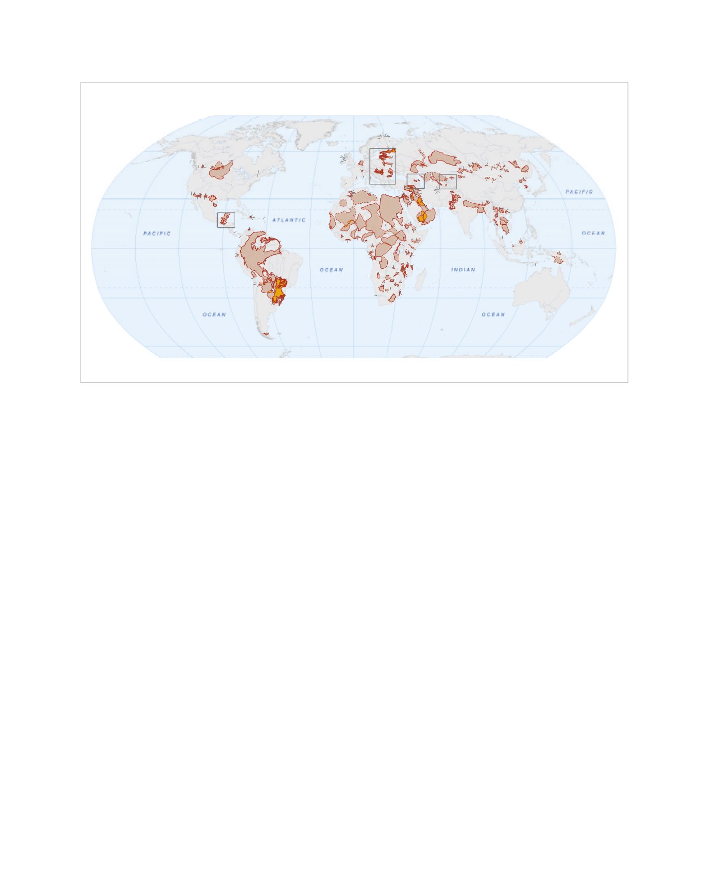
Transboundary Aquifers of the World
180°
120°E
90°E
60°E
30°E
0°
30°W
60°W
90°W
120°W
150°W
0°
30°S
60°N
180°
A
B
C
D
E
F
G
H
I
J
K
L
1
2
3
4
5
60°S
30°N
150°E
Preparedby IGRAC
Basemaps
Country borders:ESRIWorldCountryGeneralized layer (April,
Rivers and lakes:ESRI (2009)
Mapprojection
Robinson projection,geographic coordinates,
spheroidWGS84, longitude of centralmeridian 0º.
© IGRAC,March 2015
Released under theCreativeCommons licence.
AttributionNon-CommercialShareAlike.
lakes
aquifer/groundwaterbody label
AB12
1
2
3
4
5
Legend
transboundary aquifers
lakes
country boundary
ice cap
tundra
subarctic
humid continental
humid subtropical
marine
mediterranean
tropicaldry
troicalwet
semi-arid
arid
highlands
Legend
transboundary aquifers
lakes
country boundary
Legend
Ocurrence and extent
aquifer
groundwater body
overlapping area
"
)
small aquifer
!
(
small groundwater body
TBAs type ofdelineation
confirmed boundary
approximate boundary
th
Geographic elements
country boundary
detailed mapsprovided on back
Legend
transboundary aquifers
lakes
country boundary
Scale1 : 135000 000
Scale1 : 135000 000
rivers
Thismap is about transboundary aquifers of theworld. It
the state of information presently available on the occ
and extent of TBAs world-wide. The map provides a
overview of these important transboundary water re
and intends to encourage further research and asse
thereof.Themap is based on themost recent inventory
ofmany activeworking groups around theworld; details
procedures for preparing thismap are available in the
‘Map compilation and labelling.’ Inventories and asses
of transboundary aquifers across the world and info
exchange between states overlying them are requi
informed transboundary aquifer governance. Thismap
contribute to raising awareness on the importance
governance of transboundary aquifers and to building
neededglobal knowledge base.
Since its establishment in 2003, IGRAC has been inv
the identification and assessment of transboundary
within the frameworks of the UNECE Transboundary
assessment,GEF InternationalWaters (IW)FocalArea
International SharedAquifer ResourcesManagement (I
initiative led byUNESCO-IHPand IAH.
Any designation employed and the presentation of
throughout this publication do not imply the expression
opinion whatsoever on the part of IGRAC, UNESCO,
theGovernment of theNetherlands concerning the lega
of any country, territory, city or area, nor of its authoriti
sovereignty on its territory and natural resource
delineation of its frontiers or boundaries. Furthermo
location and boundaries of several transboundary
have not yet been confirmed by representatives of all c
involved. In such cases, an effort wasmade to indicate
map the correspondingprovisional status.
The mission of the International Groundwater Re
AssessmentCentre (IGRAC) is to facilitate and promot
sharing of information and knowledge required for sust
groundwater resources development and management.
independent and non-profit centre, IGRAC operates
auspices ofUnited Nations Educational, Scientific and
Organization (UNESCO) and the World Meteor
Organisation (WMO). IGRAC is an in-house part
UNESCO-IHE in Delft, the Netherlands, and receives fi
support from theGovernment of theNetherlands.
ABOUTTHISMAP
DISCLAIMER
COLOPHON
World
Meteorological
Organization
Gov
Net
TransboundaryAquifersof theWorldandPopulationEstimate
TransboundaryAquifersof theWorldandClimateZones
TransboundaryAquifersof theWorldandGroundwaterResources andRecharge
(Source:SocioeconomicData andApplicationsCenter; layer name:PopulationCountFutureEstimate 2015)
(Source:WHYMAP -BGR&UNESCO)
(Source:ArcGISOnline, owner:MapingOurWorld, credits:NationalGeographic)
Edition 2015
Printed inParis by theUNESCO
InternationalHydrologicalProgramme
Source: IGRAC and UNESCO
Map of the transboundary aquifers of the world (edition 2015)