


 85 / 130

[
] 85
A B
et ter
W
or ld
soil for agriculture, but also safeguards people and ecosys-
tems against natural disasters such as floods, fires, wind
and droughts. Ecosystem functions provide three main
advantages to human well-being – provisioning services,
e.g. water, productive grazing, cultivated crops, firewood,
building materials and medicinal plants; cultural services –
identity and place attachment; and regulating services such
as sediment retention, water absorption, flood regulation and
drought resilience.
In the case of the Ntabelanga and Lalini dams, the most
valuable ecological infrastructure is robust, fertile soils that
can resist erosion and provide a basis for improved agri-
cultural production. The further degradation of ecological
infrastructure in these catchments is the greatest threat to
the adaptive capacity of people and ecosystems. The robust-
ness of ecosystems and their functionality can be enhanced
by increasing natural vegetation cover, improving the organic
What nature delivers to us,
good or bad
Nature: Ecological Infrastructure
Public assets (e.g. finance) and
infrastructure (e.g. dams)
Mainly exogenous human-influenced
drivers – markets, politics, economy
Mainly endogenous
human-influenced drivers
–physical, conceptual
and motivational
infrastructure
Including weather and
ecosystem services’
responses to land and
resource use
Adaptive planning management
and governance
Learn Connect Trust
Human assets and well-being, including human
capacity to act, human values, opportunities,
responsibilities, equity, voice identity
Direct drivers – all Natural Resource Management
interventions, good or bad
Awareness Willingness
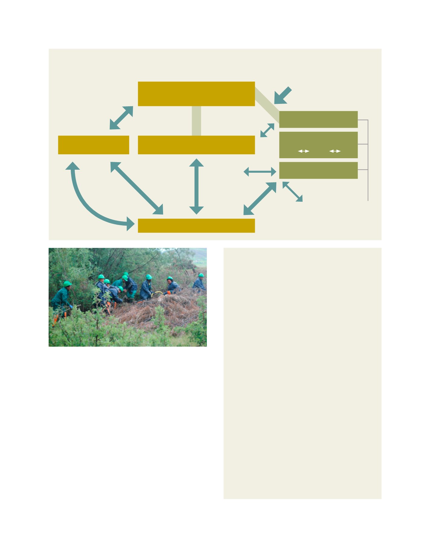
A social-ecological systems framework for integrated natural resource
management, understanding and action in the Tsitsa catchment
Early on, NLEIP scientists and managers drew up a central
guiding social-ecological framework (see diagram above) to
help conceptually guide and direct actions, processes and
interlinkages. As one example of its use, participants can
locate their particular initiatives somewhere on the diagram,
and are also then able to better see their interlinkages to other
elements; and overall, NLEIP administrators and funders are
able to see which elements have which levels of attention.
PLUS
Two key overraching issues to remember throughout
1. Multiple interconnected scales
(local – regional – global) and across multiple corresponding
levels of governance
2. A constantly changing milieu
with thresholds and tipping points, involving history, power
changes, baselines, trends and scenarios
At the centre of the hub are natural resource management
interventions which impact on ecological infrastructure (bottom
block), in turn influencing ecosystem services (left block; the
reason for the curved return arrow is to remind us that sometimes
certain exogenous natural happenings like floods or droughts can
impact ecological infrastructure without necessarily any human
involvement). The ecosystem services in the left block go on to
interact with human assets and well-being in the top block. The
three closely-positioned blocks on the right refer to endogenous
human infrastructures/capitals which play a key role in influencing
NRM, whilst the strong arrow coming from the top right-hand
corner depicts exogenous human drivers usually out of our control
as local residents or actors. The bridges (non-arrowed connections)
designate overlaps where it may be difficult to place an attribute in
one or the other block category, or the two blocks and their links
may need more unpacking than shown here, in order to be clear.
Two overall messages (1 and 2) apply throughout.
Clearing silver wattle in the Upper Umzimvubu to improve streamflow,
biodiversity and grazing potential in a land user incentives programme with
Conservation South Africa
Image: DEA RSA
Source: DEA RSA